At first glance, Death Valley National Park might seem austere and overwhelming, an arid desert landscape where nothing grows. But, once you look a bit closer, you’ll find that it’s a vast playground of bizarre geology. From towering sand dunes, to high-elevation juniper forests, to psychedelic badlands, it’s a must-hike National Park for desert lovers.
As the largest National Park outside of Alaska, Death Valley is often referred to as the land of superlatives. Not only is it the lowest and driest place in North America, it’s also held the record for hottest temperature ever recorded.
Such an extreme landscape means that hikers must plan their visits carefully, as many campgrounds either close or do not take reservations during summer months.
We recommend visiting Death Valley in early spring, late fall, or winter, when temperatures are cooler and the nearby Sierra Nevada Mountains are socked in with snow.
Always check the weather forecast and park website before heading out, as nighttime temps often hover above 100 degrees, and flash floods can quickly render park roads and certain trails inaccessible.
Though its not as flashy as many National Parks, there’s still an abundance of wildlife that calls Death Valley home. Coyotes, tarantulas, bats, bighorn sheep, and rare Devil’s Hole Pupfish all live in this desert.
In recent years, wild burros, a relic from mining prospectors in the 1800s, have run rampant in the park and are competing against native plants and animals for precious resources.
One of 26 designated Dark Sky Parks in the system, Death Valley is a perfect place to check out a myriad of constellations in the night sky and view the Milky Way. Take advantage of warm nighttime temps and kick back with a beer and a rock for a chair to see the show.
It’s also a great National Park for people who are seeking accessible hikes — with a pair of knobby tires, the infamous Badwater Basin quickly becomes a barren wilderness ripe for exploration.
Related Read: An Epic Guide to California’s 14ers: Hiking & Climbing the High Peaks
The Best Hikes in Death Valley
Hiking in Death Valley will make you feel like you’re walking in a far-off moonscape, painted in shades of rainbow by pops of different minerals. It can feel lonely and expansive all at once, because of the harsh conditions and the sheer size of the place.
1. Badwater Salt Flat
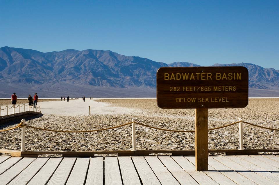
Why you should go: Feel the crunch of salt against your boots and revel in standing on the lowest spot in North America on this easy trek.
- Distance: 1 – 2 miles
- Elevation Gain: negligible
- Difficulty: Easy
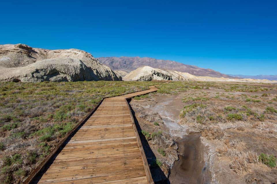
Regardless of your fitness level, viewing the Badwater Salt Flat should be at the top of your list if you’re visiting Death Valley. This flat hike provides people the chance to explore the lowest point on the continent and offers striking views of the surrounding mountains.
From Furnace Creek, head south for 25 minutes on Badwater Road and park in the paved lot (several large spaces exist for trucks and RVs). From here, visitors can follow an interpretive, ADA-accessible boardwalk. The signs describe the unique geology of the area and how this salt flat is formed by rapidly evaporating water from the sparse annual rainfall.
The real fun begins when you step off the boardwalk and onto the flat itself. Marvel at the massive, 200-mile expanse of squiggly, geometric salt formations while taking an easy stroll across the desert floor.
It’s five miles (each way) to the other side, but most hikers only explore for a mile or so before turning around and walking back to the solace of the cool air-conditioning in their car.
Related Read: 6 Phenomenal Backpacking Trails in Joshua Tree National Park
2. Golden Canyon, Gower Gulch, and Badlands Loop
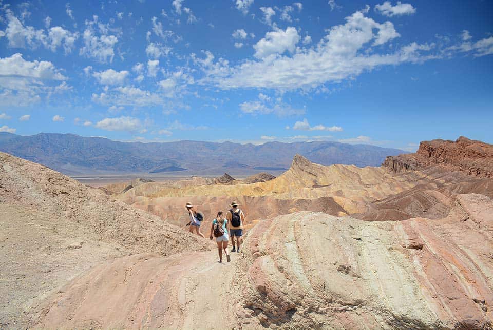
Why you should go: See the veritable “best of Death Valley” on this longer loop that passes Zabriskie Point, Golden Canyon, and Manly Beacon.
- Distance: 7.5 miles
- Elevation Gain: 834 feet
- Difficulty: Moderate
If you’ve only got time to do one hike on your trip to Death Valley National Park, make it this one.
Starting just five minutes from the visitor center in Furnace Creek, the Golden Canyon and Gower Gulch Loop will take you past some of the area’s most famous sights.
Unlike many other hikes in Death Valley, there’s a paved road all the way to this trailhead. From the visitor center, turn right onto CA-190 E, then turn south down Badwater Road. After two miles, take a sharp left onto Golden Canyon Road and park in the paved parking lot.
Hike through goldenrod-tinted badlands and crane your neck to snap a photo of Manly Beacon, one of the hike’s most notable rock formations. The trail meanders up and down on rolling desert hills for the majority of the 7.5 miles.
Travelers here have the option of cutting the walk short and turning around near Manly, but we think the extra effort to check out Zabriskie Point is well worth a few more sweat drops on your brow.
Related Read: 20 Incredible Hikes in Southern California
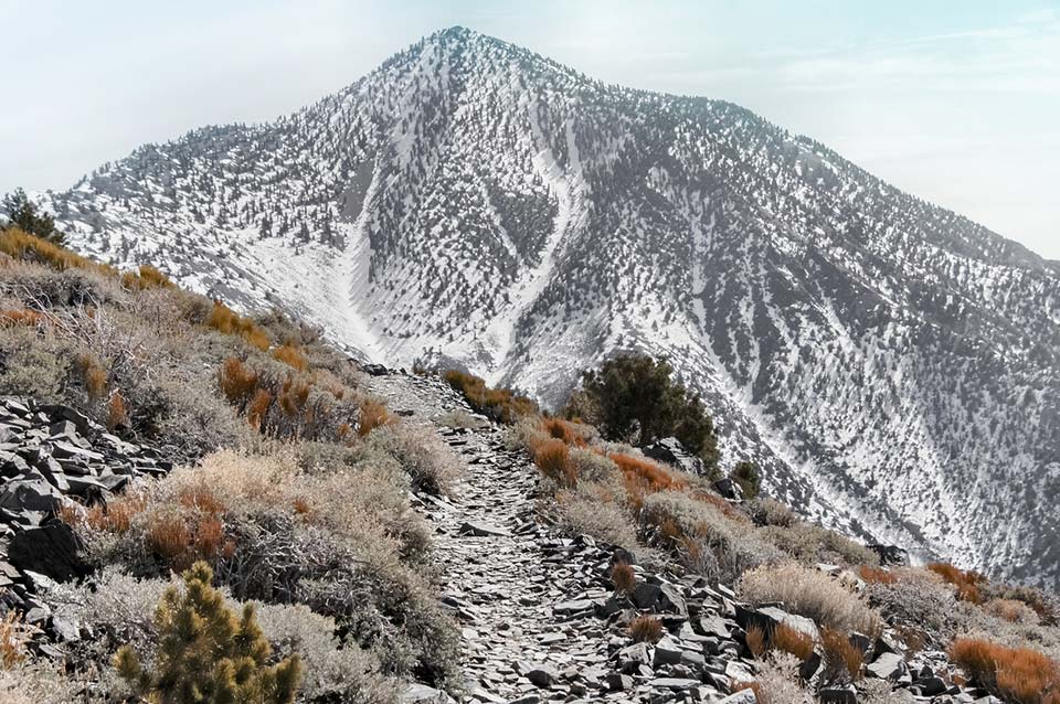
3. Wildrose Peak
Why you should go: Take in a sweeping view of Badwater Basin and summit a desert peak on this all-day trek into Death Valley’s high mountains.
- Distance: 8.5 miles
- Elevation Gain: 2,200 feet
- Difficulty: Challenging
Wildrose Peak is an excellent hike for visitors who want to challenge themselves when the valley temperatures are too hot for comfort. It’s also a fantastic way to experience panoramic views of the park without slogging up the far more difficult Telescope Peak.
Just remember check the snow conditions before embarking on this journey in the winter!
To begin, follow Emigrant Canyon Road to the parking area for the Charcoal Kilns. The final two miles is a well-maintained gravel surface that should be passable in most sedans, though it’s not recommended for vehicles over 25 feet.
Park in the dirt lot and take a moment to check out these historic, beehive-shaped relics of the old west before beginning the trek.
From here, you’ll follow a dirt singletrack through desert shrubs and watch as the landscape quickly shifts into an alpine forest of pinyon pines and deliciously fragrant juniper trees.
At the summit, take in some serious views of the Panamint Mountains and the floor of Death Valley, sitting a staggering 9,000 vertical feet beneath your boots.
Related Read: The 20 Best Places to Camp in Southern California
4. Salt Creek Interpretive Trail
Why you should go: This mellow, half-mile trail is paved, ADA-accessible, and the only place in the world where you can spot a Devils Hole Pupfish.
- Distance: 0.5 miles
- Elevation Gain: negligible
- Difficulty: Easy
Beginning just off of Salt Creek Road (13 miles west of Furnace Creek), this short, accessible hike is a great side-journey for those visiting Death Valley from February to April who’d like to catch a glimpse of the endangered Devils Hole Pupfish as they spawn.
We saw a lot of pupfish in the creek. It’s so quiet and peaceful here. Great for a short walk in the morning!
These rare, iridescent blue fish have been cut off from their other pupfish relatives for over 10,000 years, and Devils Hole is the only aquaphor in which they naturally occur. They are extremely sensitive to their environment, and this strange desert concoction of 93-degree water and constant salinity creates the perfect habitat for them to breed.
The hike meanders through a salt marsh on a raised, wooden boardwalk that follows interpretive signs about the pupfish and the unique geology of this region.
Be sure to bring your binoculars along for the ride — this trail offers the best bird watching in all of Death Valley.
Related Read: The 10 Best Hikes in Joshua Tree National Park
5. Sidewinder Canyon
Why you should go: This off-trail adventure requires careful route finding, but rewards brave souls with up-close glimpses of three slot canyons, free from the usual crowds.
- Distance: 5 miles
- Elevation Gain: 1,580 feet
- Difficulty: Challenging
Due to the difficult route-finding needed on this trek, we highly recommend stopping by the Furnace Creek Visitor Center first to grab a trail description and map before you head out.
Plan to take longer than usual to complete this five mile jaunt, as the entire track is off trail.
From Furnace Creek, travel 31.5 miles down Badwater Road and turn left, down an unmarked gravel road. At the end of the road, park in the dirt lot.
When you start hiking, don’t get impatient and turn into the first, most obvious canyon, unless you fancy wasting time. From the parking lot, travel southeast for 1,000 feet before reaching the entrance to Sidewinder Canyon proper.
As you hike up the wash, you’ll be greeted by three separate slot canyons to the south of the use trail. Explore to your heart’s content!
If you love off-trail scrambling, this is the hike for you. Squeeze, shimmy, climb, and maneuver your way into each of them, taking time to soak up the marvelous conglomerate rock formations you’ll find the deeper you go.
Just don’t forget your headlamp!
Related Read: 12 Best Camping Spots in Anza-Borrego Desert State Park
6. Mosaic Canyon
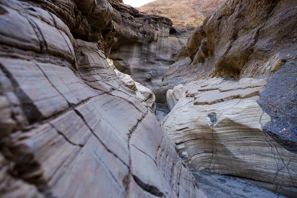
Why you should go: Try your hand at some moderate rock scrambling on this four mile route through a breccia slot canyon.
- Distance: 4 miles
- Elevation Gain: 960 feet
- Difficulty: Moderate
Mosaic Canyon is a fantastic day trip for anyone looking to dally in slot canyon navigation without the higher commitment or route-finding challenges often associated with Sidewinder Canyon.
Just 2.3 miles down Mosaic Canyon Road out of Stovepipe Wells Village sits a gravel parking lot that marks the beginning of the trek. From here, head south into the large wash that marks the entrance to the canyon itself.
At the 0.3-mile mark, you’ll see the rock walls narrow considerably, providing an up-close look at the fascinating breccia and marble swirls that give the canyon its name.
At the 1.3 mile mark, the hike gets a little spicy, and those who want to try their hand at scrambling should veer left and climb up a narrow section to the side of a large boulder.
Continue hiking and scrambling up and around the boulders and one dryfall before reaching the turnaround point at a rock amphitheater surrounding another, taller 30-foot tall dryfall.
Related Read: 14 Unforgettable Hikes in Northern California
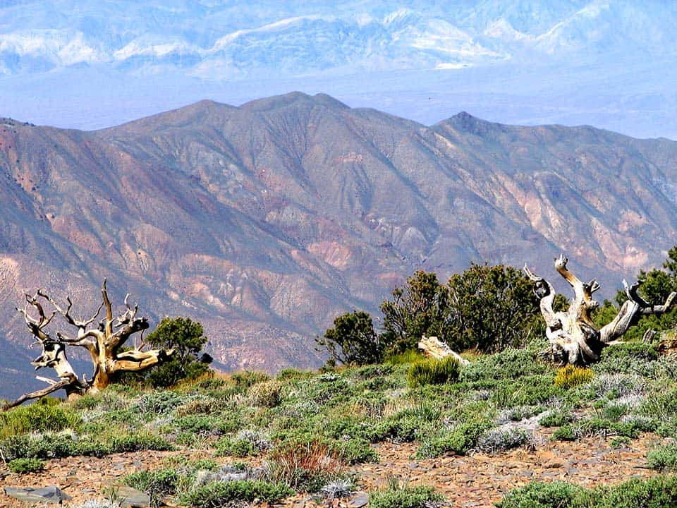
7. Telescope Peak
Why you should go: Beat the heat and take in the best views of the park from this 11,049-foot summit nestled in a grove of junipers, pinyon, and bristlecone pines.
- Distance: 14 miles
- Elevation Gain: 2,885 feet
- Difficulty: Challenging
Telescope Peak is one of the most challenging hikes in all of Death Valley. It’s also one of the park’s few maintained trails, climbing a leg-busting 2,885 feet from the Mahogany Flat Campground.
If you’re looking for an all-day challenge away from the heat of Badwater Basin, this is an epic choice you won’t soon forget.
Park as close as you can to Mahogany Flat Campground off of Wildrose Canyon Road (4×4 may be required), then get ready to ascend.
The trail swings around Rogers peak and boasts commanding views of Death Valley and the Panamint Range right away. It passes through the rocky expanse of Arcane Meadows, then traverses a wide plateau before climbing up again through a forest of ancient bristlecone pine trees.
From here, the summit of Telescope Peak will feel tantalizingly just out of reach. Continue hiking up, through the low-oxygen air and the final series of switchbacks until you have reached the summit proper.
Now it’s time to enjoy the magnificent view.
Badwater Basin, the lowest point in North America, sits 11,331 feet below your boots. That’s a bigger drop than from the summit of Mt. Whitney to the Owens River Valley!
When you’re done taking in the jaw-dropping views, simply turn around and hike back the way you came from.
Related Read: 9 Adventurous Things to Do in Yosemite National Park, California
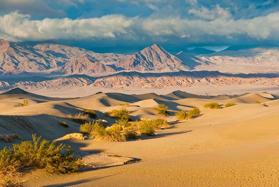
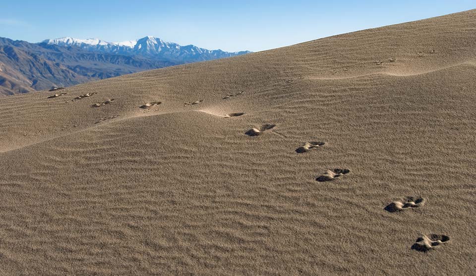
8. Mesquite Flat Sand Dunes
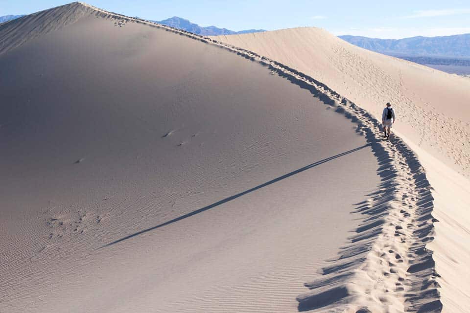
Why you should go: Slide, shimmy, and surf your way down this massive series of sand dunes, located in the heart of Death Valley.
- Distance: 1 – 2 miles
- Elevation Gain: Varies, usually 100-200 feet
- Difficulty: Easy
The most accessible of all the dunes in Death Valley National Park, the Mesquite Flat Sand Dunes serve hikers epic views of the Grapevine Mountains while offering a unique chance to scale the steep edge of a massive sand dune.
These dunes are adjacent to the Stovepipe Wells Village, a 30-minute drive from the more populated Furnace Creek area. There’s a large, paved parking lot suitable for trucks and RVs, and from here, hikers can choose their own adventure and journey up the sandy hills and valleys as they please.
Though travelers are welcome to explore the dunes to their heart’s content, most people only venture one mile or so into the sandy fray, opting to treat this like a quick, in-and-out roadside attraction. It’s one mile each way and 185 vertical feet to the summit of the high dune.
The real magic of this famous Death Valley feature is found in taking your time to wander the dunes at dawn or dusk. That’s when the hot desert sun paints everything in pastel pinks and shades of lavender, electrifying the ordinarily static expanse.
Related Read: 9 Best National Parks to Visit in December
9. Panamint Dunes
Why you should go: Escape the tourist throngs and get off the beaten path on this eight mile, unmarked trek to one of Death Valley’s most remote dune fields.
- Distance: 8 miles
- Elevation Gain: 1,028 feet
- Difficulty: Challenging
Don’t let the fact that you need a high clearance vehicle to get to this trail deter you — it’s one of the few that consistently makes the “best of” lists for Death Valley, and it’s easy to see why.
The hike traverses one of the least visited and, therefore, most pristine sand dune areas of the entire park, leaving you and your camera alone to enjoy the vast quiet of the desert.
From Panamint Springs, head east on CA-190 and turn left onto an unmarked dirt road after 4.5 miles. In just 5.8 miles, the road will bend and you’ll see a little dirt parking lot up ahead to the left.
From here, you’ll just be able to make out the dunes to the north. Head towards them on an unmarked, cross-country route across rocky, gravelly terrain.
There are four different dunes to explore here, all with sweeping views of the Panamint Mountain Range.
This trip can also be done as an overnight backpack during cooler months, leaving you in the blissful solitude of sand and stars once the sun sets. Just be sure to grab a backcountry permit from the Furnace Creek Visitor Center or Stovepipe Wells Ranger Station before you head out.
Related Read: 5 of the Best Canadian National Parks for Adventurers of All Ages
10. Dante’s Ridge (Mount Perry)
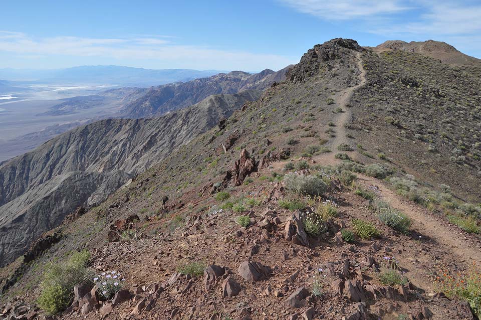
Why you should go: Take the path less traveled and soak up some 360-degree views of Death Valley on this out and back along a famous ridgeline.
- Distance: 8.5 miles
- Elevation Gain: 1,200 feet
- Difficulty: Moderate
Dante’s Ridge ascends a narrow dirt singletrack across the ridgeline leading to Mount Perry (5,739 feet) and offers up some seriously stunning views along the way. It’s also one of the few excursions in Death Valley that has a paved road all the way to the parking area, making it an ideal choice for those in sedans or shorter RVs.
Hike Dante’s Ridge in shoulder season to beat the heat of the valley and the unpredictable snow of the park’s upper peaks.
Recommend going early morning or afternoon. Beautiful views! Total solitude! No trails,.
Once you’re done snapping pictures with the crowds at Dante’s View, turn around and begin hiking northeast along the ridge. Though there is no official signage or trail for this trek, the thousands who have hiked it in the past have created a well-worn use trail that should be easy to follow.
As you climb the ridgeline, you’ll be treated to epic panoramas on all sides, with Badwater, Telescope Peak, and Mt. Whitney all to your left and the dry expanse of the desert floor and Ryan Benchmark to your right. This is a hike to bring your cameras on, folks!
About 3.5 miles into the hike, you’ll come upon a band of rock that requires some minor scrambling to get around.
For those looking to go the distance to Mt. Perry, continue north, in the same direction. However, many more casual hikers choose to turn around here and head back to their vehicle.
Either way, this dramatic landscape will not disappoint.
Explore More
Get epic travel ideas delivered to your inbox with Weekend Wanderer, our newsletter inspiring more than 10,000 readers every week.
Seen in: California, Death Valley, Hikes, National Parks, West