Eugene, Oregon is a hiker’s mecca with majestic moss, rocky ridgelines, and everything in between. The best part: it’s all accessible from the downtown area.
Eugene is an underrated gem for hiking trails in Oregon. The city may be better known as “TrackTown, USA,” since it’s the home of Historic Hayward Field and hosts many premier track and field events. But, it’s also surrounded by endless trails and mountains. I’ve lived and hiked here for over a decade and I’m still discovering new places around Eugene to explore on foot. Eugene has an impressive network of trails and parks in the city itself. And, if you drive just a short distance outside of city limits, you can access even more trails and secluded nature.
One thing I love about hiking and camping in the Willamette Valley is that you can count on trail access nearly 365 days a year, without needing snowshoes or microspikes. Eugene rarely gets snow, so the nearby trails stay primed for hiking year-round. Pro tip: You might get a little wet during the rainier winter months, so always pack your rain layers. It’s hard to narrow down my favorites, but you can’t go wrong with any of the trails on this list.
Editor’s note: This article was updated on November 16, 2023 to include the Spencer Butte Trail and the Twins Trail, as well as updated information and trailhead beta on the remaining hikes.
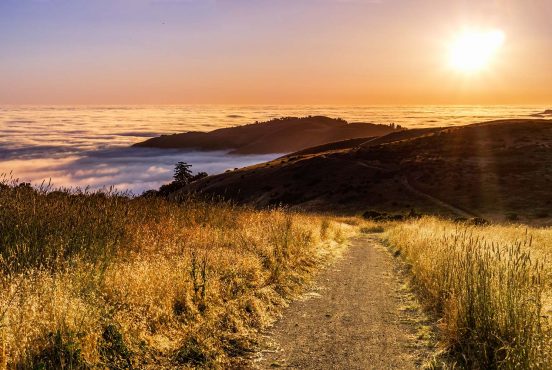
Spencer Butte from Ridgeline Trail
- Distance: 4.9 miles
- Elevation Gain: 1,184’
- Difficulty: Moderate
Why You Should Go: To hike to the highest point in Eugene and grab views from the city to the Cascades.
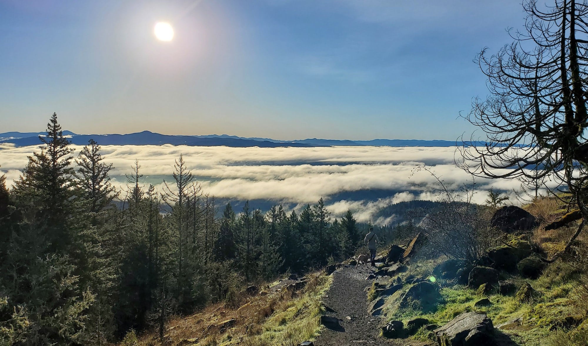
Spencer Butte is a classic Eugene hike, for good reason. I’ve been trekking up this hill for over 10 years, and it still blows my mind that I can travel from my front door to its summit in just a few miles. On a clear day, you can see some of the most iconic volcanoes in Oregon, including the Three Sisters and Diamond Peak. And on a foggy day, this trail often carries you above the clouds so you can enjoy some winter sun and a glorious view of the mountains peeking out over the soupy mist.
There are a few different ways to hike to the top of Spencer Butte. The highest trailhead on Willamette Street can get you less than a mile from the summit. I recommend parking at the lower lot on Willamette (the 52nd and Willamette Trailhead) to grab a little more forest time on your way to the top. If you want even more miles, you can park at the Martin Street Trailhead for a 6-mile round trip hike with roughly 1,600 feet of climbing.
From the 52nd and Willamette Trailhead, hike up the Ridgeline Trail for around 1.25 miles. When you get to the intersection with the trail to the summit, take a right and follow the signs toward the top. (You’ll know you’re going the right way if you keep hiking in the up direction.) When you reach the summit, find a good boulder to sit and take in the views. You can see everything from the city to the Cascades from the top of Eugene.
Mount Pisgah West Summit Trail
- Distance: 2.8 miles
- Elevation Gain: 1050’
- Difficulty: Moderate
Why You Should Go: For bottom-to-top views of the Willamette Valley and the Cascades.
Mount Pisgah is the other major hill in Eugene, but it feels very different from its neighbor to the west. Whereas you climb through a thick fir forest on Spencer Butte, Mount Pisgah is an open, grassy oak savanna with views from bottom-to-top. I love going for sunrise and sunset hikes on Mount Pisgah, because even if I don’t nail the timing for reaching the summit for the best colors, I can still see plenty of action along the way.
There’s a whole network of trails across the 2,363-acre park, with many options to extend your hike, but the most popular route to the top is Beistel’s West Summit Trail (or Trail #1). This starts from the West Trailhead (which requires a parking fee) and is another well-signed trail system in Eugene. The trail is a bit steep in the first half of the climb but becomes more gradual as you get higher up. Enjoy views of the Willamette River below as you climb and take in the Cascades to the east when you reach the summit.
For a fun bonus hike, there’s also a 21-acre arboretum at the base of Mount Pisgah, where you can explore the park’s nature trails and learn more about the local ecology.
Ridgeline Trail: Fox Hollow to Mount Baldy
- Distance: 3.5 miles
- Elevation: 715’
- Difficulty: Moderate
Why You Should Go: To explore some of Eugene’s most accessible nature.
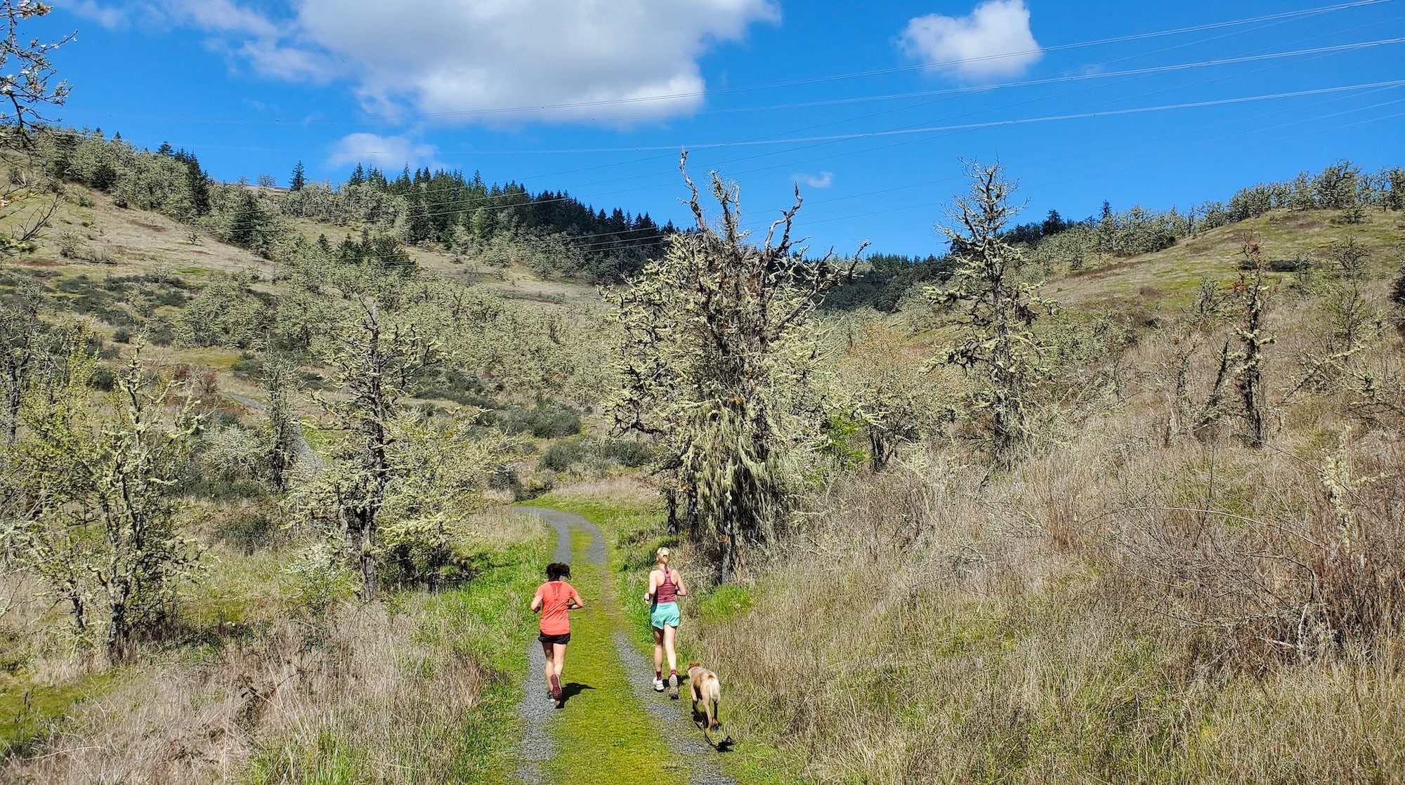
The Ridgeline Trail system is one of my favorite things about Eugene. It might not be as jaw-dropping as a hike through Oregon’s alpine wilderness, but it’s an incredibly accessible way to get on a trail and get into nature any day of the week. You can hop from the best bagel shop in town to a trailhead in about a mile and I’ve never stopped feeling grateful for such easy and convenient trail access where I live.
This loop is a great slice of the Ridgeline Trail. It carries you through the forest and up to the summit of Mount Baldy, where you can see the city below and mountains on the horizon. There’s a cute little bench and a grassy meadow on top if you want a scenic spot to snack along the way.
Start at the Fox Hollow Trailhead and hike toward Dillard. When you get to Dillard, hike either direction up Baldy and make it loop by taking the other trail back down. Then cross Dillard again and head back toward Fox Hollow. The whole Ridgeline Trail system is well signed and easy to navigate.
Goodman Creek Trail
- Distance: 8 miles
- Elevation Gain: 1,541’
- Difficulty: Moderate
Why You Should Go: To immerse yourself in a magical stretch of forest.
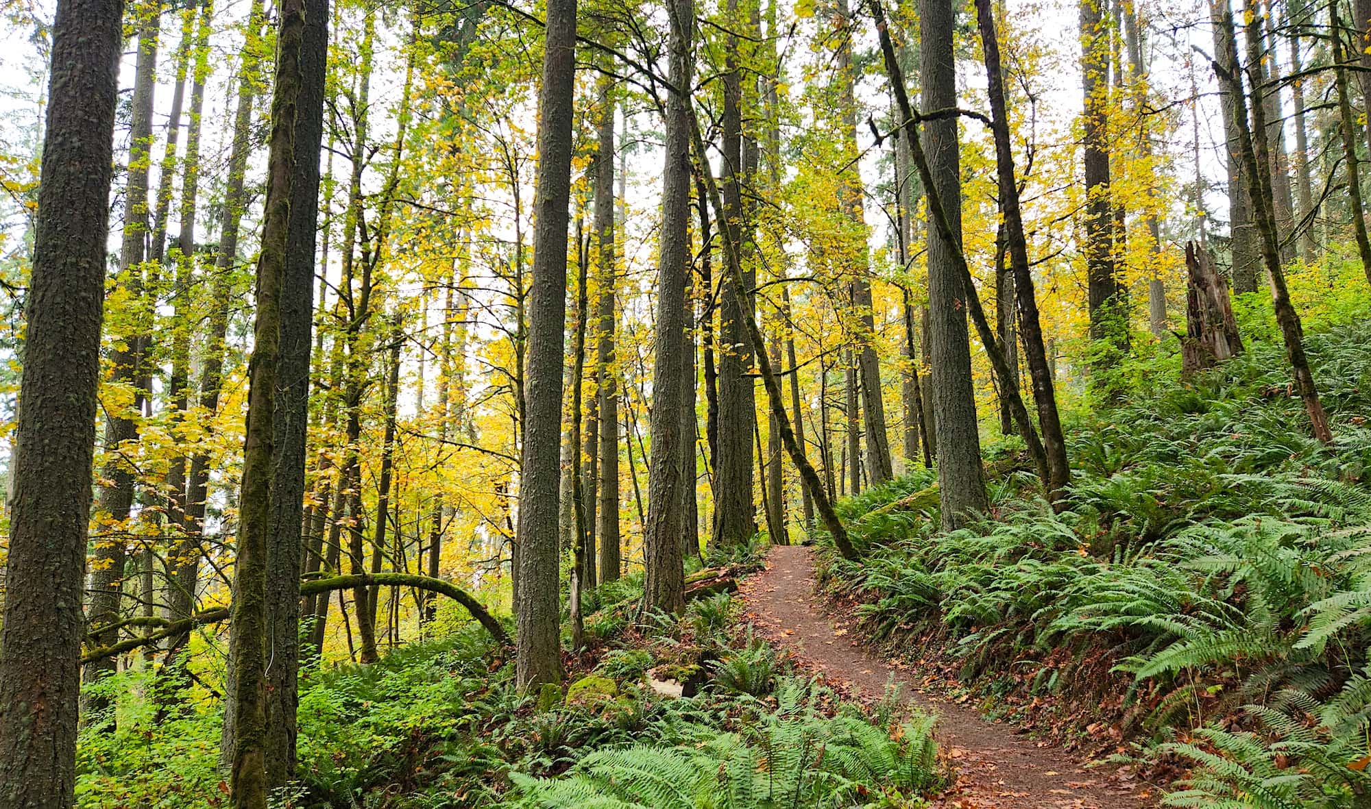
The Goodman Creek Trail doesn’t take you to a summit, but that doesn’t mean you’ll miss out on views. This trail is a scene straight out of Ferngully, with lush undergrowth, majestic evergreens, moss galore, and rocky creeks. I love visiting this trail in the spring, when the rain has turned the forest into 50 shades of green.
Start from the Hardesty Trailhead, which is just 21 miles east of Eugene, and climb up the Hardesty Trail until you get to the intersection with the Goodman Creek Trail. Hook a right onto Goodman Creek Trail and keep hiking until you reach the end of the trail at Forest Road 5833. If you want a longer hike (and a summit), you can cross the road and continue on the Eagle’s Rest Trail. Or, turn around and head back to the trailhead for a lovely out-and-back hike.
Hardesty Mountain
- Distance: 10.7 miles
- Elevation Gain: 3,464’
- Difficulty: Challenging.
Why You Should Go: For a heart-pumping and strength-building climb.
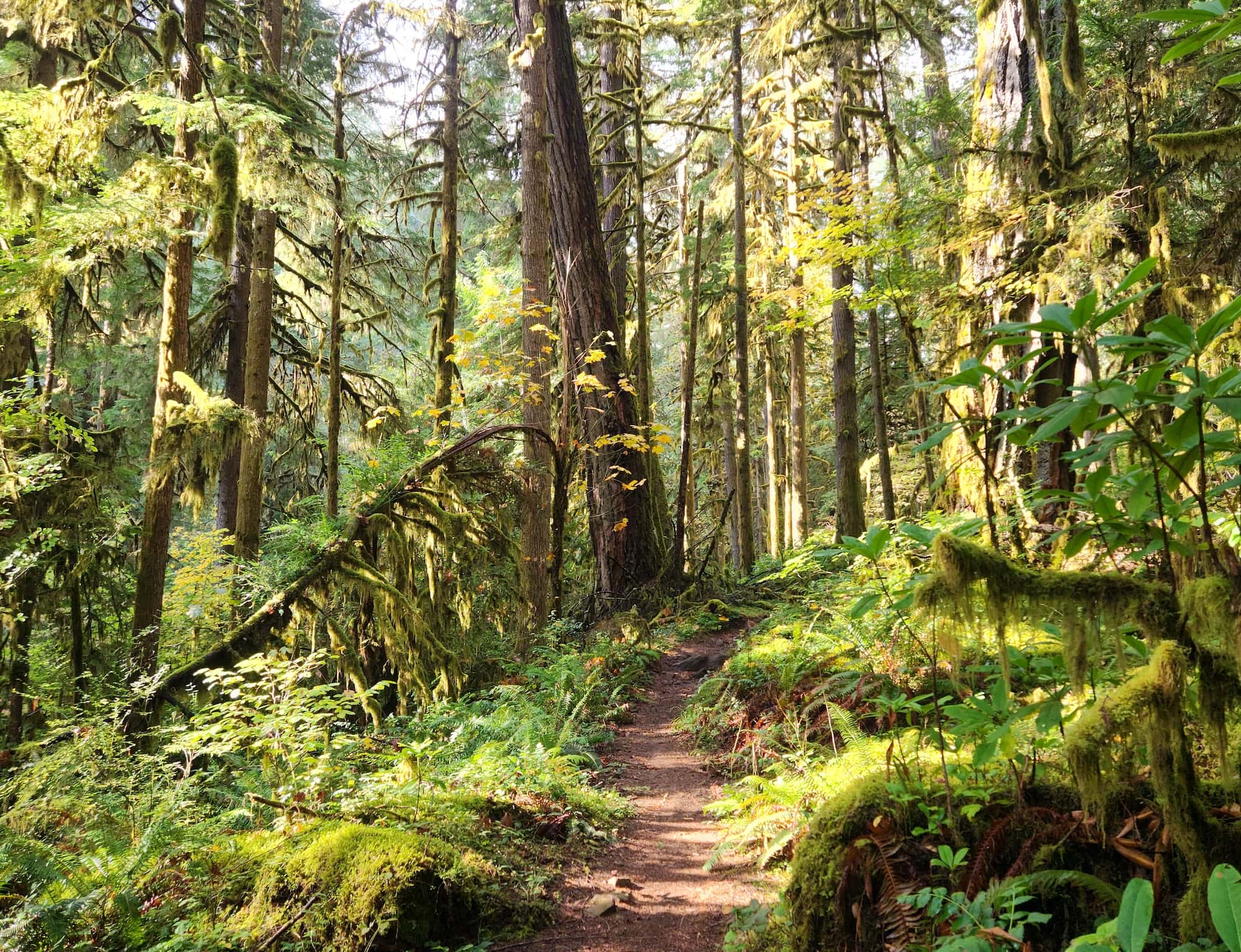
I do a lot of longer distance trail adventures and Hardesty is one of my go-to spots for a solid training hike. It’s a steady, rather relentless climb from the trailhead to the summit and it’s helped me get ready for many big mountain objectives. I love when I get into a rhythm of visiting this trail on a weekly basis and can feel how the climb gets easier – and I get stronger from doing it.
Hardesty doesn’t have the most spectacular summit (it’s actually one of the most anticlimactic summits I’ve ever seen), but the trail is anything but boring or unimpressive. It weaves through a beautiful forest, full of classic Pacific Northwest vibes. So, leave your hopes for a good summit view behind and enjoy the journey to the top.
It tends to be a quieter trail, but it is also open to mountain bikes and equestrian riders. It’s likely you won’t see many people on your hike, but be ready to share the trail with other users, especially on a prime day for mountain biking.
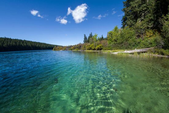
McKenzie River Trail Clear Lake Loop
- Distance: 4.8 miles
- Elevation: 239’
- Difficulty: Easy
Why You Should Go: To see an underwater forest.
Clear Lake was formed when a volcanic eruption sent a giant lava flow charging toward the McKenzie River three thousand years ago. The lava redirected the river and backed up the water to form a lake. The forest that once lined the riverbanks of the McKenzie became submerged in the new waters, where it remains today. You can spot the ancient forest 120 feet below the turquoise waters, from either the water or the trail.
Start your hike from the Upper McKenzie River Trailhead (on the opposite end from the popular Blue Pool Trail) and hike south toward the lake. When you get to the intersection with the Clear Lake Loop Trail, take the trail and hike along the western edge of the lake. The trail will cross the Clear Lake Resort on the southern end of the lake, pick the trail back up through the campground and continue onto the eastern side of the water. When you get back to the intersection with the McKenzie River Trail, hike back to the trailhead through the forest. (The loop is really more of a lollipop.)
If you want to explore more of the area, the McKenzie River Trail travels 26.4 miles along the river and tours ancient lava flows, a pair of magnificent waterfalls, Blue Pool, and many miles of lush, old-growth forest. You can continue south past Clear Lake or stop at one of the other trailheads along Route 126. I’ve done the trail in one-go several times and I highly recommend it if you want a bigger adventure and a full tour of the McKenzie River’s varied and stunning terrain.
The Twins Trail
- Distance: 6.8 miles
- Elevation: 1,910’
- Difficulty: Moderate
Why You Should Go: To get a taste of the Cascades.
Willamette Pass is the closest place to get into the Cascades from Eugene and it’s well worth the hour drive. I think of this area as Eugene’s backyard alpine wilderness and it’s one of my favorite places to hike, camp, and ski.
The Twins Trail offers a great taste of the Cascades, with stunning views of the Cascades from Mount McLoughlin to Mount Jefferson. You’ll hike through a quiet hemlock and lodgepole pine forest to reach the summit, but don’t underestimate the scenery on this part of the hike. The trees in this wilderness are some of the most majestic trees I’ve ever seen, so soak up your miles in the forest on your way to the top.
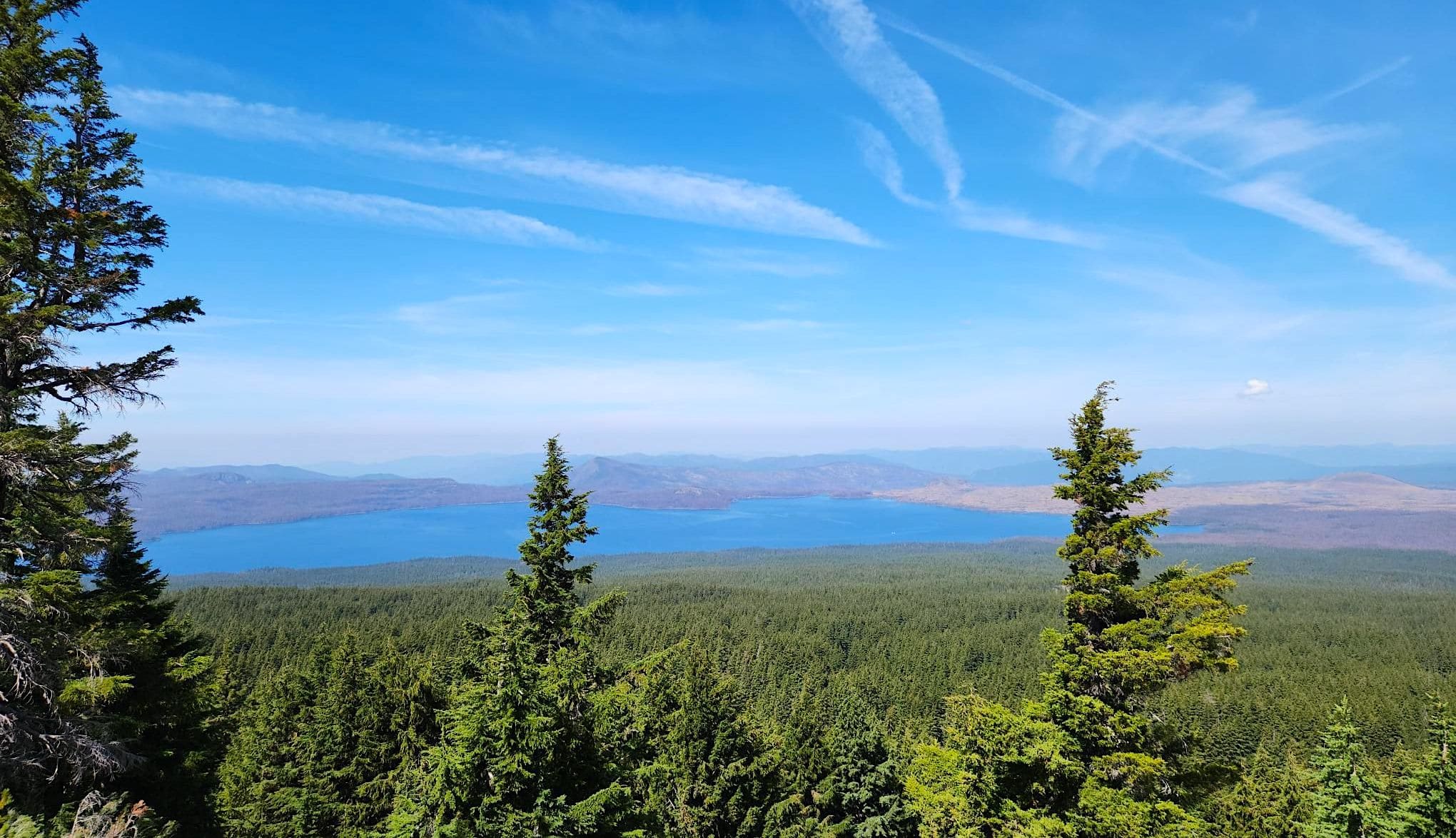
The trail crosses the Pacific Crest Trail (PCT) about two miles up from the trailhead. Keep hiking through this intersection (unless you want to add on a few PCT miles in either direction, which is a great option). When you get close to the top, you’ve got a a steep climb over loose pumice soil to the top of the cinder cone. But, it’s a quick grind and you’ll be rewarded with views of Waldo Lake and Cascade volcanoes in every direction. You can continue on for a short trek to the top of the neighboring mountain (hence the name ‘The Twins’) or turn around and head back down to the trailhead. This area does get snowed-in during the winter months, so plan your visit for summer or fall.
Explore More of Oregon
Sign up for our free email to join thousands of readers getting epic travel, hiking, camping and gear ideas every week.