Whether it’s lush rainforests, misty coastal jaunts, or steep inclines to jaw-dropping summits, Oregon has a wide variety of hikes for the intrepid to explore. These are just a few.
The first time I set foot on an Oregon trail was in Portland’s Forest Park, a massive urban wilderness space that’s home to 80 miles of trails and over 5,000 acres of ferns and fir trees.
That small slice of a city park blew me away so much that I soon decided to move to the Pacific Northwest so I could spend many more days and miles on the trails around the region. If it was that good within city limits, I couldn’t imagine what else was out there.
Since moving to Oregon over a decade ago, I’ve discovered that Oregon is the gift that keeps on giving in the hiking department. Oregon hosts a diverse and absolutely magical range of ecosystems that includes lush rainforests, dramatic coastlines, rocky deserts, and stunning mountains. It’s got something for everyone and a bit of everything for someone who loves to see—and hike—it all.
Best Hiking Trails in Oregon
Narrowing the hiking options down to a list of greatest hits is nearly impossible. It would take a much longer list to cover all of Oregon’s must-hike trails. But, you can’t go wrong with any of these hikes.
The Green Lakes/Soda Creek Loop
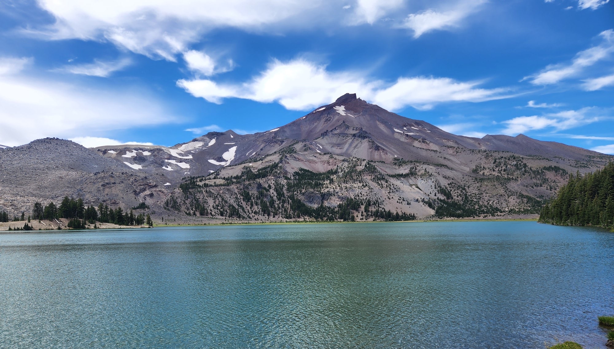
Why You Should Go: To hike through some of the most stunning alpine terrain in Oregon.
- Distance: 12.1 miles
- Elevation gain: 1,627 feet
- Difficulty: Moderate
The return on investment with the Green Lakes Trail is huge. In just a few miles, you’ll get to one of the most scenic stretches of Oregon’s alpine. (And this is coming from someone who’s explored a lot of Oregon’s alpine.) This loop carries you past a series of alpine lakes sandwiched between South Sister and Broken Top, two of the biggest and most dramatic mountains in Oregon. Each lake is bluer than the last. And at the right time of day, you can catch the volcanos reflecting on the glassy waters below.
The loop starts from the Green Lakes trailhead with a 4.5-mile climb through the forest. (Don’t forget your Central Cascades Wilderness day-use permit if you’re hiking from June 15-October 15.) The trail meanders over switchbacks, and it’s a mostly gradual ascent toward the treeline with a few waterfalls and creek crossings along the way. Once you crest the top of the forest, you’ll wander beside a creek until you get to the high meadows and lakes. Have your camera ready to go and your jaw ready to drop for the main attraction. It really is that good.
Watchman Peak Trail
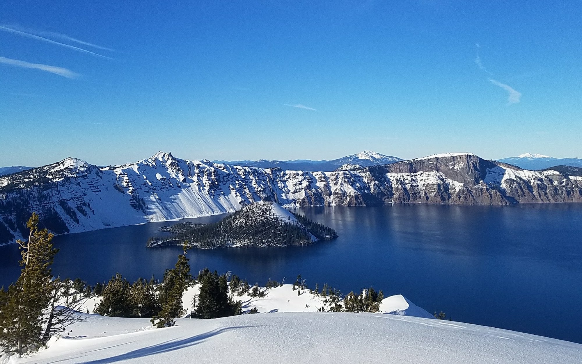
Why You Should Go: For a bird’s eye view of the deepest lake in America.
- Distance: 1.7 miles
- Elevation gain: 400 feet
- Difficulty: Moderate
While Oregon offers over 30 million acres of public land, there’s actually only one national park in the entire state: Crater Lake National Park. But what Oregon lacks in national park numbers, it makes up for in wow factor. Crater Lake, which was formed during a volcanic eruption 7,700 years ago, is the deepest lake in America and one of the deepest lakes in the entire world. Its waters are almost too blue to believe and it’s definitely worth a visit to see it for yourself.
Many people tour the park by car, as you can drive along the rim of the lake and stop at many scenic overlooks. But, it’s worth getting out of the car to stretch out your legs on any of the hiking trails in Crater Lake National Park. Nab an even better view of the lake from one of the mountains that line the crater.
Watchman Peak is a great trail for a hike above the lake. Start at the Watchman Peak Trailhead and in less than two miles, you’ll reach an active fire lookout tower and one of the best views in the park. You can also peep Wizard Island, the cinder cone island that sits majestically in the middle of the lake.And if you happen to be visiting in the off-season, bring a pair of snowshoes and wander along the rim of the lake. In my personal opinion, Crater Lake might be even more spectacular in the wintertime when the bright blue water is surrounded by snow.
McKenzie River Waterfall Loop Trail
Why You Should Go: For the chance to see giant waterfalls rushing over lava.
- Distance: 2.6 Miles – With options to add-on
- Elevation gain: 380 feet
- Difficulty: Easy
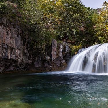
If you like to go chasing waterfalls, head to Oregon – there are tons of waterfall hikes for the most intrepid of hikers. The wettest parts of the region get over 200 inches of rainfall a year, which keeps the waterfalls flowing and primed for hiking.
The McKenzie River is home to Sahalie Falls and Koosah Falls, two of the biggest and wildest waterfalls I’ve ever seen. They’re both tucked beneath towering evergreens and rush over jagged lava dams. On sunny days, you can see rainbows spouting off the falls. Or, in the right conditions, you can spot intrepid kayakers taking a heart-pumping plunge over the 80 to 100-foot drops. Sahalie Falls also has a wheelchair-accessible viewing platform. In my experience, this spot is a popular one. Get there early if you want to beat the crowds and enjoy more serenity along the way.
The waterfall loop is a relatively short and gentle tour of the waterfalls. But, if you want to hike a little further and see more of the river, you can keep going on the McKenzie River Trail, which travels 26.4 miles along the river. The trail wanders past Clear Lake, ancient lava flows, the waterfalls, Blue Pool, and many miles of lush, old-growth forest. There are also a handful of other trailheads along Route 126, so you can mix and match your McKenzie River hiking experience to see all of the sights at the top of your list.
South Sister
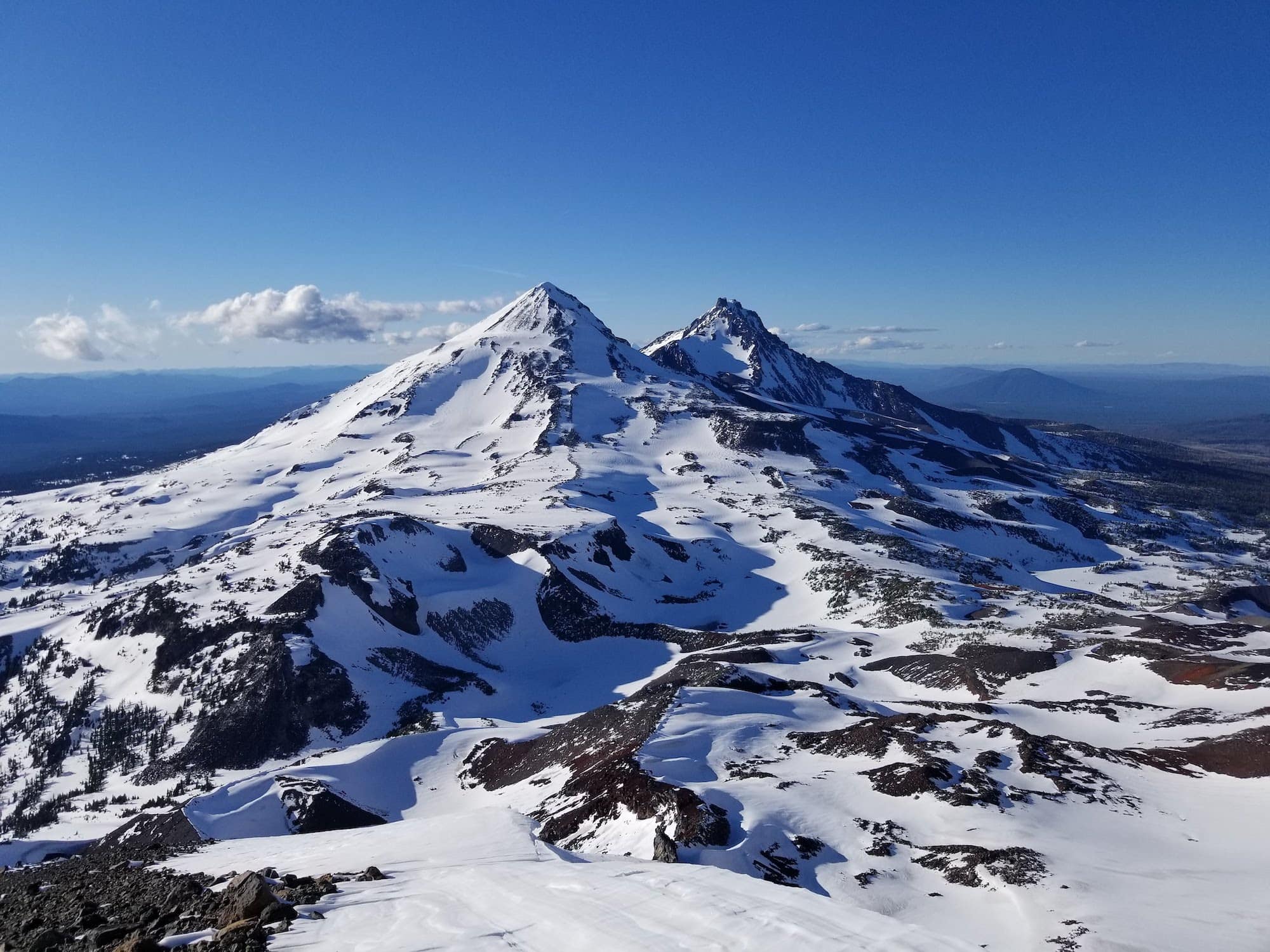
Why You Should Go: To summit one of the biggest, and most majestic, Cascade volcanoes in Oregon.
- Distance: 11.6 miles
- Elevation: 4,986 feet
- Difficulty: Difficult
There’s nothing quite like summiting one of the Cascade volcanoes, and this is one of the best hikes near Bend. They’re such an iconic part of the horizon in the Pacific Northwest and it’s a fulfilling and jaw-dropping experience to climb to the highest peaks in the state.
South Sister is one of the more approachable volcanoes to hike because it’s not an especially technical trail. But, it’s definitely not an easy climb. Be prepared with the right gear, attitude, and fitness for a long and hard grind. The last mile of trail pitches up a nearly 45-degree slope, covered in loose sand and scree. It’s a slog to get to the top and with a summit at 10,358 feet, sea level lungs will probably feel the altitude. But you’ll be majorly rewarded for your effort. The summit opens up to 360-degree volcano views, including one of my favorite spots to admire at South Sister’s sibling mountains, Middle and North Sister.
Many people also do South Sister as a two-day hike if that’s more your style Note: Central Cascades Wilderness day-use permit is required for day hikes from June 15-October 15. Permits are also needed for backpacking from the Devil’s Lake Trailhead.
Saint Perpetua Trail
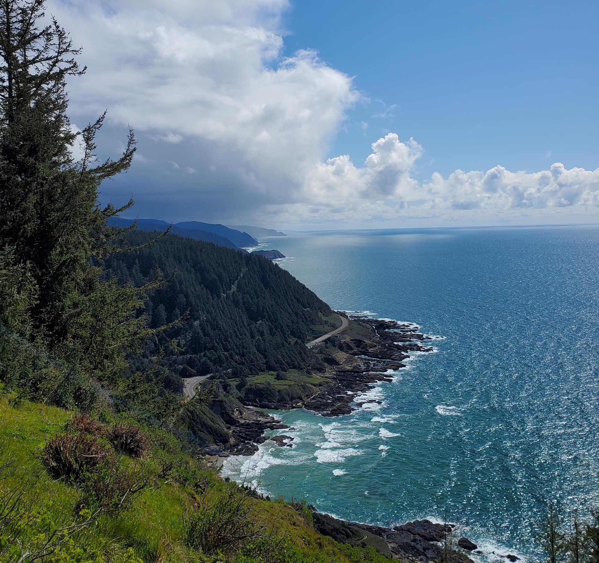
Why You Should Go: To see the dramatic coastline of the Pacific Ocean.
- Distance: 4.4 miles
- Elevation Gain: 800 feet
- Difficulty: Moderate
The Oregon coastline is packed with dramatic hikes and spectacular slices of seashore. The coast is full of jagged cliffs and rocky beaches that might be even more beautiful on a stormy day.
Saint Perpetua Trail, located in the Cape Perpetua Scenic Area, will carry you to an overlook where you can find panoramic views of the coastline. It’s one of my go-to spots to bring out-of-town visitors because it’s such a stunning place to take in the coast. The trail climbs through a lush spruce forest before depositing you into a meadow where you can start to glimpse the Pacific. On a clear day, you can see 150 miles from the high point on the trail.
If you visit during mid-December–mid-January or late February–May, you may spy gray whales migrating in the distance. About 20,000 of them make the trek between the Bering Sea and Mexico twice a year. The parking area is also a quick walk from tidepools between Cook’s Chasm and the Devil’s Churn if you visit at low tide and want to see some of the smallest wonders of the ocean after taking in the big views.
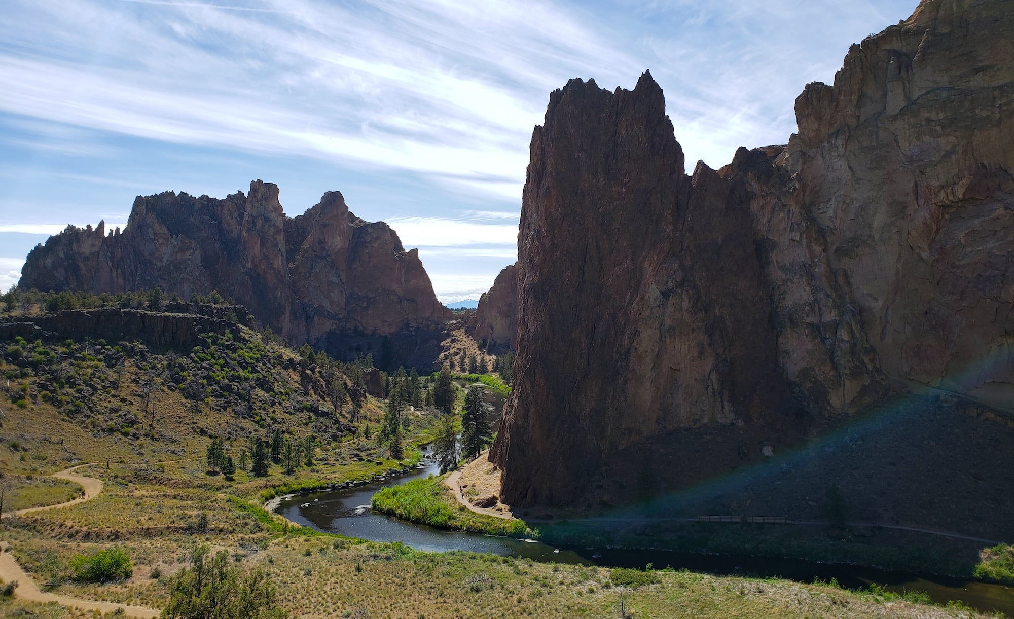
Misery Ridge
Why You Should Go: To check out Oregon’s wild and beautiful desert. It’s not all big mountains and lush rainforests in the Pacific Northwest.
- Distance: 6.2 Miles
- Elevation Gain: 1,761 ft
- Difficulty: Moderate
Don’t let the name scare you away. This hike in Central Oregon’s Smith Rock State Park is anything but miserable. The final section is steep, but the views along the way will power you to the top.
Smith Rock may be best known as a climbing destination. The world-famous state park boasts thousands of climbing routes, but it’s also full of incredible hiking. The trail to Misery Ridge will give you stunning views of the rocky canyon, where spires of volcanic ash tower over the Crooked River. It travels past some of the park’s most striking features and notable climbing routes, including Monkey Face, a 350 foot tower that truly does look like a monkey. Most of the trail is gentle but the final .68 miles and 600 feet are quite steep. You might want to bring trekking poles for the last push to the top.
Zigzag Canyon Overlook
Why You Should Go: To grab jaw-dropping views of Oregon’s most iconic mountain.
- Distance: 4.4 miles
- Elevation Gain: 800 feet
- Difficulty: Moderate
Mount Hood should be on every hiker’s must-see list. While the climb up the highest point in Oregon is a technical ascent that requires both mountaineering skills and gear, there are lots of hikes up and around Mt. Hood.
The hike to Zigzag Canyon is one great way to do it. You’ll get huge views of Mount Hood from the very first step and see how much the mountain can change in just a few miles. You’ll start at the historic Timberline Lodge (fun fact: this is where The Shining was filmed) and take the Pacific Crest Trail (PCT) to the rim of the canyon. This route is a fun way to get your eyes on Mount Hood and your feet on the PCT. At the right time of year, you’ll be treated to wildflowers galore. The trail also overlaps with the Timberline Trail, which circumnavigates the entirety of Mount Hood. It’s also worth a trek if you have more time. It’s one of my favorite trails in the PNW thanks to its endless and diverse views of the mountain. (The Timberline Trail clocks in at just over 40 miles, with 10,000’ of climbing along the way. No small feat!)
The trail takes you to a rim above the rugged Zigzag Canyon, where a glacial river flows below. You can keep going into the canyon if you want more mileage, or turnaround and head back to Timberline for fancy hot chocolate with a view.
Angel’s Rest
Why You Should Go: To experience the amazing scenery of the Columbia River Gorge, from the forests to the vistas.
- Distance: 4.5 Miles
- Elevation Gain: 1500 feet
- Difficulty: Moderate
The Columbia River Gorge is one of the most awe-inspiring parts of Oregon. I was mentally packing my U-Haul to move to Oregon the first time I saw it while visiting from the East Coast. From stunning vistas to famous waterfalls to wildflower-flooded meadows, this river canyon is a hiker’s paradise.
Angel’s Rest is a viewpoint on the southern end of the canyon that will give you a bird’s eye view of the Columbia River cutting through the Cascade Mountains. It’s got a few steep and rugged sections of trail, but it’s worth the climb. The trail starts from the Angel’s Rest Trailhead and weaves through a thick forest, with a few waterfalls and a small creek along the way. It then travels up to a rocky viewpoint where you can see the massive Columbia River below and mountains all around you.
Pro tip: Hike at sunset to avoid the crowds and get an even more magical view of the Columbia River Gorge.
Explore the Pacific Northwest
Get epic travel ideas delivered to your inbox with Weekend Wanderer, our newsletter inspiring thousands of readers every week.
Seen in: Crater Lake National Park, Hikes, Oregon, West