South Dakota often flies under the radar, but it’s teeming with world-class sightseeing that will please the most intrepid travelers.
When exploring a new state, it often feels like there’s so much to see yet not enough time to do it all. In South Dakota, there are seven national park units to visit–and you can feasibly hit them all in a week since all but one are less than a two-hour drive from each other. In the seven days that I spent in the state, I was amazed at how much ground I was able to cover and how many attractions I checked off my list.
Although technically part of the midwestern region of the United States, it’s obvious that South Dakota has a culture and history strongly associated with the Old West. From gunslingers like “Wild Bill” Hickok and Calamity Jane and authors like Laura Ingalls Wilder to bold explorers and navigators like Sacagawea and Lewis and Clark, the state has many famous characters pass through and settle on the land. Historical sites abound, along with museums, cultural centers, and monuments dedicated to Native American tribes.
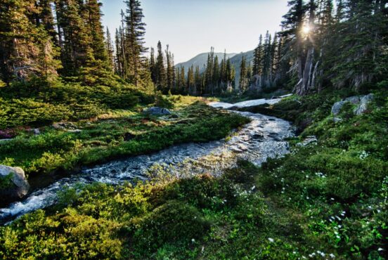
While summer is by far the most popular time of the year for tourism in South Dakota, spring and fall offer cooler temperatures that make outdoor recreation a lot less sweaty. Leaf-peepers take note: during our late September visit, the vivid colors of autumn were on full display in the trees wherever we hiked and drove. You may want to clear up some space on your phone as there is plenty to photograph, whether you’re walking the Presidential Trail at Mount Rushmore, boating on the Missouri National Recreational River, or exploring the Minuteman Missile National Historic Site. Find yourself a sweet South Dakota glamping spot, tuck in, and get exploring the Mount Rushmore State.
Jewel Cave National Monument
Why You Should Go: Geology enthusiasts and adventurers will enjoy the ranger-guided tour that illuminates the history of this glittering cave. Winding trails above ground offer beautiful views of grassy meadows and stately ponderosa pines.
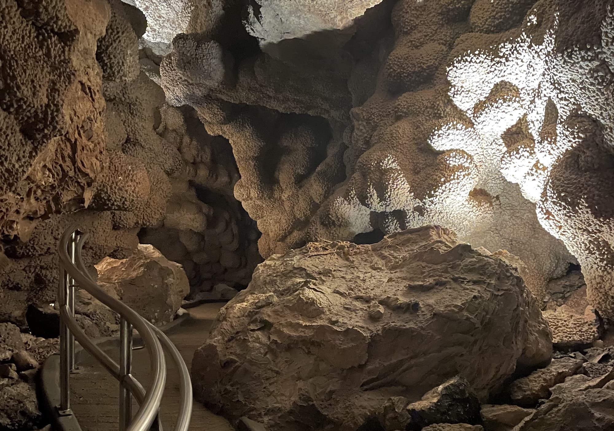
Jewel Cave is not only a stunning wonderland to explore, it has a fascinating backstory that a park ranger shared as we descended nearly 240 feet underground to walk among breathtaking rock formations. In 1900, prospectors Frank and Albert Michaud heard whistling coming from a small hole in the canyon. Peeking inside, they saw the sparkling surface of what they thought to be quartz. Eager to harvest the cave’s riches, the brothers got to work enlarging the opening with dynamite blasts–only to discover that the glistening bounty was not jewels but calcite.
And the cave that was originally presumed to be small? It’s actually the third longest in the world with over 215 miles of passageways that have been mapped…so far. In 1908, President Theodore Roosevelt declared Jewel Cave a National Monument, making it the first cave ever to receive that designation.
Jewel Cave National Monument is open year-round and has peak visitation during the summer months. To go inside the cave, you’ll need to purchase a ranger-guided tour. While you won’t find actual jewels inside, you will view intricate geological formations like boxwork, cave popcorn, flowstone, and striped draperies referred to as “cave bacon.” Above ground is a 1,279-acre park, where I enjoyed a peaceful walk among tall, aromatic pines and took in beautiful views of the surrounding hills. There are two self-guided surface hiking trails that are free to the public: the Roof Trail (0.25 miles) and the Canyons Trail (3.5 miles).
Mount Rushmore National Memorial
Why You Should Go: Seeing this massive sculpture up close provides a sense of awe that is worth experiencing. Tag along on a free tour to hear the backstory of how the memorial came to be.
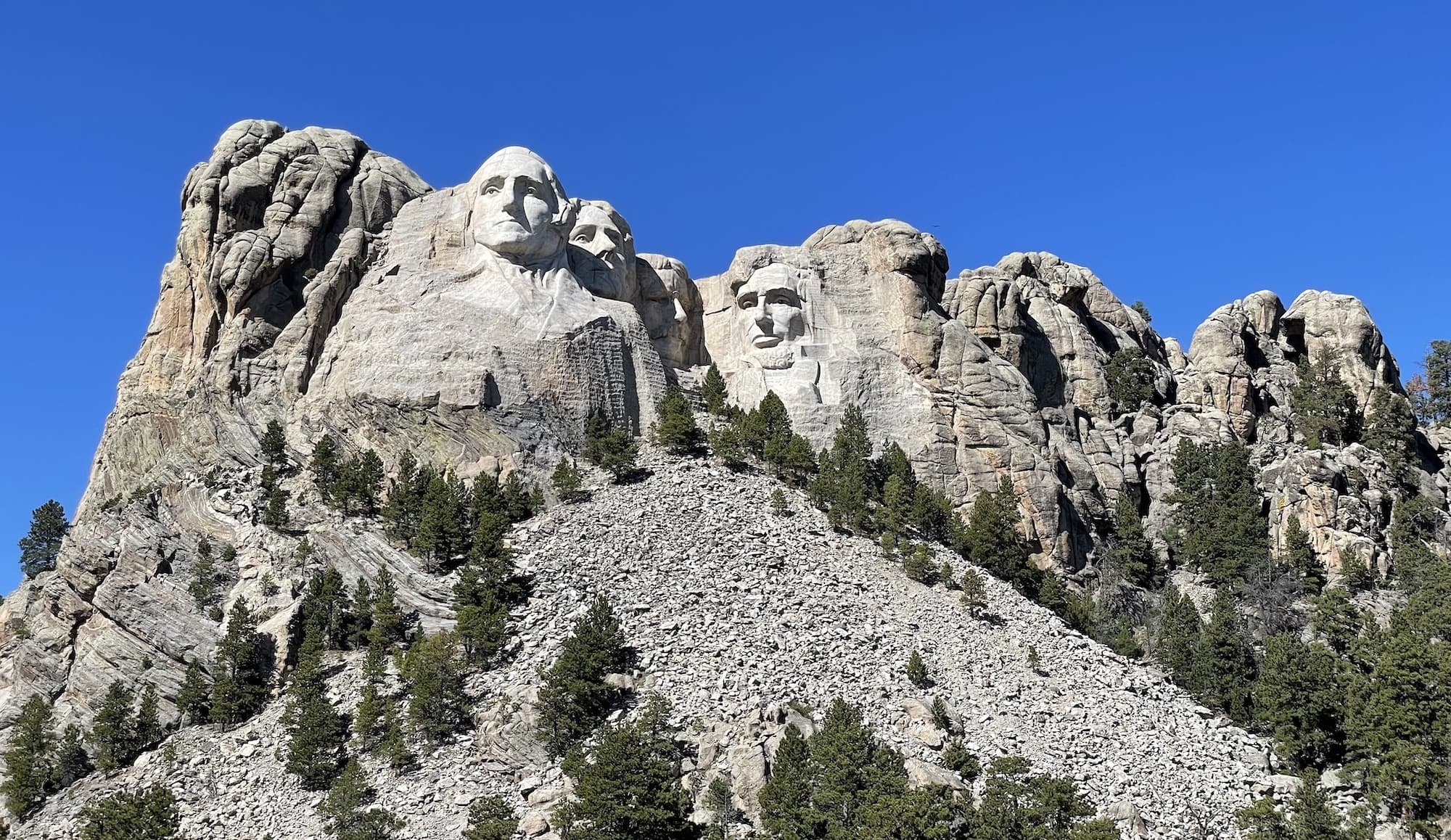
Even from the highway, you can see the iconic faces of presidents George Washington, Thomas Jefferson, Teddy Roosevelt, and Abraham Lincoln peering out from the granite cliffs. Construction of Mount Rushmore–which was intended to draw tourists to South Dakota during the tourism boom of the 1920s–spanned 14 years.
During my visit, I walked the Presidential Trail, an interpretive path with various stopping points for viewing and photographing different angles of the monument. At just 0.6 miles long, the path runs from the Visitor Center to the Sculptor’s Studio, where you can see worker tools and a plaster model of Borglum’s original, much more complex design. Free tours are offered throughout the day, and I learned a lot about the history of Mount Rushmore’s construction from 30 minutes of walking and listening to a knowledgeable park ranger.
Fun fact: If you bring binoculars, you’ll be able to spy the old drill bit stuck in Washington’s right eye. During construction, it was too risky to remove, so it was left there to rust away over time.
June and July are the most popular times of year for tourism. During the summer, the site sees up to 25,000 people per day. However, if you’re like me and prefer to avoid heat and crowds, then late September to early October is the best timeframe for planning a visit.
Note: While this towering monument of our country’s greatest leaders is awe-inspiring, it also comes with a good deal of controversy since the sculpture carves into traditional Sioux land. Those wanting to visit an Indigenous monument might consider Hill City’s Crazy Horse Memorial commissioned by Chief Henry Standing Bear.
Lewis & Clark National Historic Trail
Why You Should Go: Driving along the Lewis and Clark Trail allows you to retrace the explorers’ famous expedition, and there are plenty of historic sites, museums, and recreation areas along the way where you can hike, bike, camp, and fish.
Winding nearly 4,900 miles across 16 states–from Pittsburgh, Pennsylvania, to the mouth of the Columbia River in Oregon–the Lewis & Clark National Historic Trail traces the famous explorers’ historic cross-country journey. The Trail’s purpose is to commemorate the Lewis and Clark Expedition with an interpretive path that the public can enjoy and learn from.
The section of the Lewis & Clark National Historic Trail that runs through South Dakota starts along I-9 near the southeastern corner of the state and continues through the Missouri River up by the North Dakota border. It features several visitor centers, museums, and historic sites, including the Akta Lakota Museum and Cultural Center and the Bad River Encounter Site.
There are various points of interest all along the trail in South Dakota: on the northern end, head to Mobridge and the Standing Rock Indian Reservation to visit a memorial to Sacagawea and Sitting Bull. Near the southeastern portion of the trail, check out the Lewis and Clark Visitor Center at Gavin’s Point Dam in Yankton, then take a brief but beautiful hike on the popular 1.2-mile Gavin’s Point Nature Trail. Summer is the most popular time of year for tourists to explore the trail, especially for those planning to enjoy fishing or boating in the Missouri River along the way.
Wind Cave National Park
Why You Should Go: Inside the cave, explore the world’s most extensive array of boxwork rock formations. Above ground, enjoy miles of free trails and spot wildlife throughout a rare mixed-grass prairie.
Stand at the entrance of Wind Cave, and you’ll quickly understand the reason for its name. The gust of air that is forced out of the cave’s opening–referred to as “cave breathing”–results from its inside air pressure system working towards equilibrium with the outside air pressure system. If that doesn’t blow you away (pun intended!), the profusion of complex geological formations inside the cave will.
Wind Cave has a lot of bragging rights: it was the first cave to be designated a national park, it contains the world’s largest concentration of boxwork formations (honeycomb-patterned calcite blades), and it is the densest cave system on earth. And, according to the Lakota creation story, Wind Cave is where the first bison and humans emerged.
Above ground, there are a variety of hiking trails (over 30 miles of them!) to explore in the park’s 33,970 acres of prairie and forest. There is no fee for hiking these trails, but visitors must purchase tickets for a ranger-guided tour to go inside the cave–and capacity is limited. While tickets can be bought in advance on the website or over the phone, you can also get them first-come first-serve style at the visitor center on the day of the tour. Just be aware, this popular attraction sells out quickly, so your best bet is arriving as early as 6:30 am to buy tickets in person.
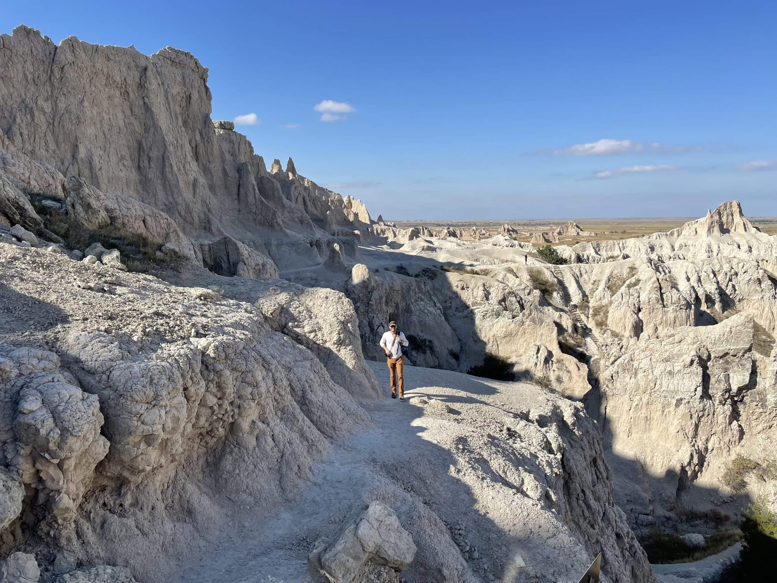
Badlands National Park
Why You Should Go: A visit to South Dakota is not complete without taking a drive or hike through this jaw-dropping, alien-like landscape of buttes, spires, and canyons.
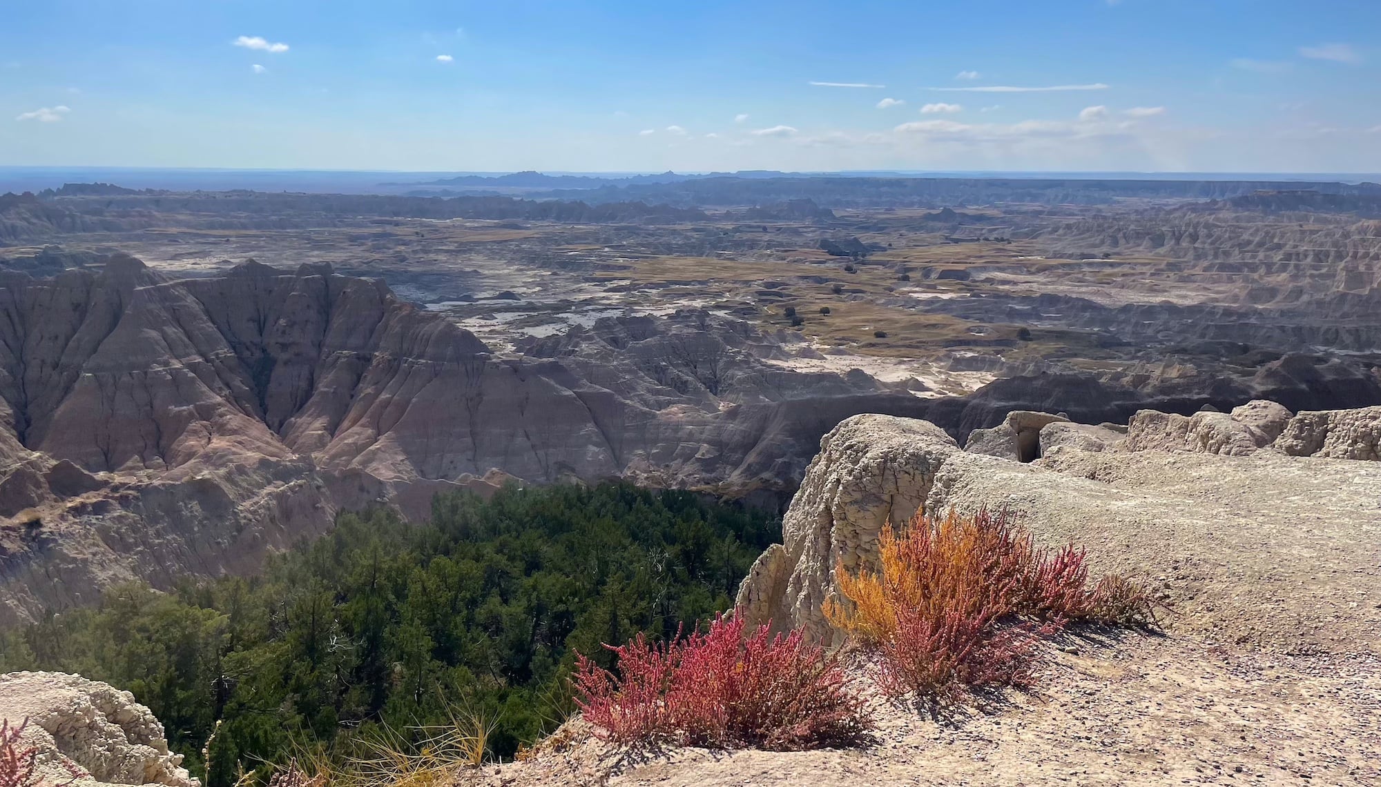
Spanning 244,000 acres, the array of pinnacles, buttes, and canyons of Badlands National Park are almost overwhelmingly beautiful. Taking it all in, I had to wonder: with views this good, why the bad name? Luckily, my question was answered. Before air-conditioned cars with water bottles in the backseat, traversing this complex landscape was a hellish ordeal. The Lakota people dubbed the dry, rugged, and oppressively hot area “mako sica,” which translates to “land bad.” Years later when the unique terrain was up for designation as a national park in 1922, the name “Wonderland National Park” was proposed. But, “Badlands” won out.
To enter the park, there is a $30 entrance fee (valid for seven days) for private vehicles. Badlands National Park is open year-round and is a hotspot for summer vacationers. For nicer weather and fewer crowds, I recommend planning a visit during the cooler seasons. My favorite is autumn, when the foliage is glowing with warm colors.
Driving the Badlands Loop Scenic Byway is a must. I found myself frequently turning the car into overlook pull-offs to photograph majestic spires and bison roaming the distant prairie. It was the gift that kept on giving: when we thought we found the best angle, the next vantage point blew us away. If you’re a hiker, venture out on the several official park trails. Knock out three at one trailhead when you hike the Door Trail, the Window Trail, and the Notch Trail, which features a thrillingly steep rope-and-log ladder (it’s not as scary as it looks) and a stunning view of the White River Valley. And if one day in the Badlands isn’t enough, you can stay at one of the park’s two established campgrounds: Cedar Pass Campground and Sage Creek Campground, both of which are open year-round.
Minuteman Missile National Historic Site
Why You Should Go: One of only two places in the U.S. where you can look at a Cold War-era missile silo up close, the Minuteman Missile National Historic Site provides education and insights on the nuclear arms race between the United States and the Soviet Union during the Cold War.
Consisting of three facilities along a 15-mile section of Interstate 90, the Minuteman Missile National Historic Site is a must-see for Cold War history buffs. The Minuteman Missile Field covered the far western portion of South Dakota between 1963 and the early 1990s. This particular section houses Launch Control Facility Delta-0 with its underground Launch Control Center and Launch Facility (Missile Silo) Delta-09. Both of these facilities are preserved in their historic state.
Use the directions given on the NPS website to find the visitor center and the two launch facilities, which are open year-round. To explore the Delta-01 facility, be sure to make tour reservations in advance. Only six visitors are allowed per tour, as space in the elevator and the underground Launch Control Center is limited.
On the flip side, the Delta-09 missile silo is open to public viewing free of charge. Enter the fenced compound and peek through a glass viewing enclosure into the silo, where the non-operational Minuteman missile lies. As an added bonus, you can listen to a ranger-narrated guided tour of Delta-09 on your cell phone.
Missouri National Recreational River
Why You Should Go: The 39-Mile District and 59-Mile District of Missouri National Recreation River offer scenic hiking and biking opportunities, and you can boat, kayak, or fish on the river itself.
The Missouri River is the longest river in North America and this park is composed of two free-flowing reaches separated by the Lewis and Clark Lake. The 39-mile reach begins immediately downstream from Fort Randall Dam at Pickstown and continues to the town of Running Water. The other reach flows from a mile below Gavins Point Dam all the way to Ponca State Park in Nebraska.
The park is free to enter and draws visitors far and wide for its boating, birdwatching, fishing, and swimming opportunities. Alongside the river, there are ample paths and parks for pedestrians and cyclists. In Yankton alone, there are over 40 miles of trails for hiking and biking. After obtaining a free permit, visitors can also camp in three locations in the park–Goat Island, Green Island, and Bow Creek Recreation Area (which is actually located on the Nebraska side of the river). There are scenic drives to take in the area as well: cruise along the Native American Scenic Byway or drive along the Oyate Trail to enjoy the sights of the southernmost portion of South Dakota.
As far as best times to visit go, it depends on what you’re looking to do at the Missouri National Recreational River. It goes without saying that summer is the best time for a visit if swimming is on the agenda. For activities that don’t involve getting in the water, spring and fall are beautiful times of year to enjoy the Missouri River. For hot tips on where to go and what to see, stop by the visitor contact station in the park’s Yankton-based headquarters building–it’s open year-round, but closed on weekends and federal holidays.
Explore More Near South Dakota
Sign up for Weekend Wanderer, our free email newsletter offering thousands of readers epic travel and gear ideas every week.
Seen in: National Parks, South Dakota, Travel