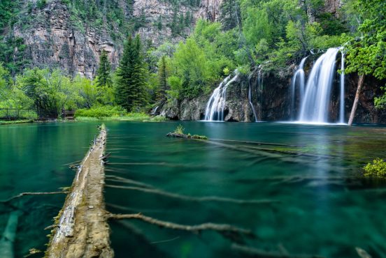
The Ice Lake Basin Trail is a tough hike to stunning views, incredible wildflowers, and electric blue alpine lakes — it’s certainly worth the climb.
The trail might be difficult, but that doesn’t seem to deter the thousands of hikers this trail sees every season. With amazing views along the way, this trail leads to one of the most beautiful destinations in Colorado.
Silverton and the surrounding areas have a unique volcanic history that created some world class hiking destinations. This ancient outdoor playground lies within San Juan National Forest, which encompasses an astonishing 1.8 million acres of land ranging from high desert to the steep alpine terrain that can be experienced at Ice Lake Basin.
Related Read: 7 Rad Campgrounds in San Juan National Forest, Colorado
Trail Details: Ice Lake Basin
| Details | Ice Lake Trail |
|---|---|
| Distance | 9.5 miles |
| Difficulty | Challenging |
| Duration | 4–5 hours |
| Trail Type | Out and back |
| Starting Elevation | 9,843 feet |
| Elevation Gain | 3,113 feet |
| Seasons | Summer, fall |
| ADA Accessibility | None |
| Dogs | Allowed on leash |
| Trail Map | AllTrails |
| Nearest Amenities | Silverton, CO |
| Directions to Trailhead | Google Maps |
| Parking | Free. No permit required. |
| Road Conditions | COtrip |
| Attractions | Alpine lakes, alpine peaks (13ers), wildflowers, backcountry skiing |
| Activities | Hiking, backpacking, fishing, trail-running, hike-to-ski, peak-bagging, unroped climbing |
Leave No Trace
As with any outing in the backcountry, please follow Leave No Trace principles while visiting Ice Lake Basin. The area is within the San Juan National Forest, and the road to the trailhead is also very popular for camping.
Please do your part to keep Ice Lake Basin accessible to all and pack out all waste — and please do not feed the marmots! As cute as they are, it does not help them to become dependent on human food, and it can have negative affects on their health, while making them reliant on humans instead of finding food in the wild. Do your best to lock up your food and trash if staying the night.
This alpine zone might look rugged and tough, but the ecosystem above timberline is very sensitive and easily affected by the actions of humans. Vegetation here is rare and can be crushed with a single footstep. Please stay on designated trails or walk along rocks as much as possible. Keeping dogs on a leash the whole time will help prevent them making an impact as well. HERE is a great resource for hiking and camping in alpine zones.
The lakes and their astonishing blue color rely on the good actions of hikers to not pollute the lake and its surrounding creeks and lakes.
The Hike
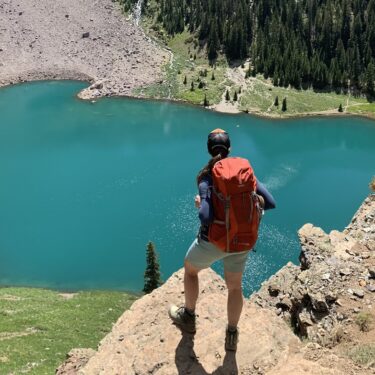
The phrase “the view is worth the climb” has never been more true than while hiking up to Ice Lake Basin! I came into this hike knowing there was a good bit of elevation gain, but figured it would be gradual. Well, the entire trail is uphill, but with some super steep sections of serious gain. This even includes one section that has a 43% grade.
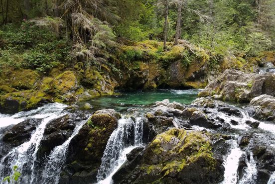
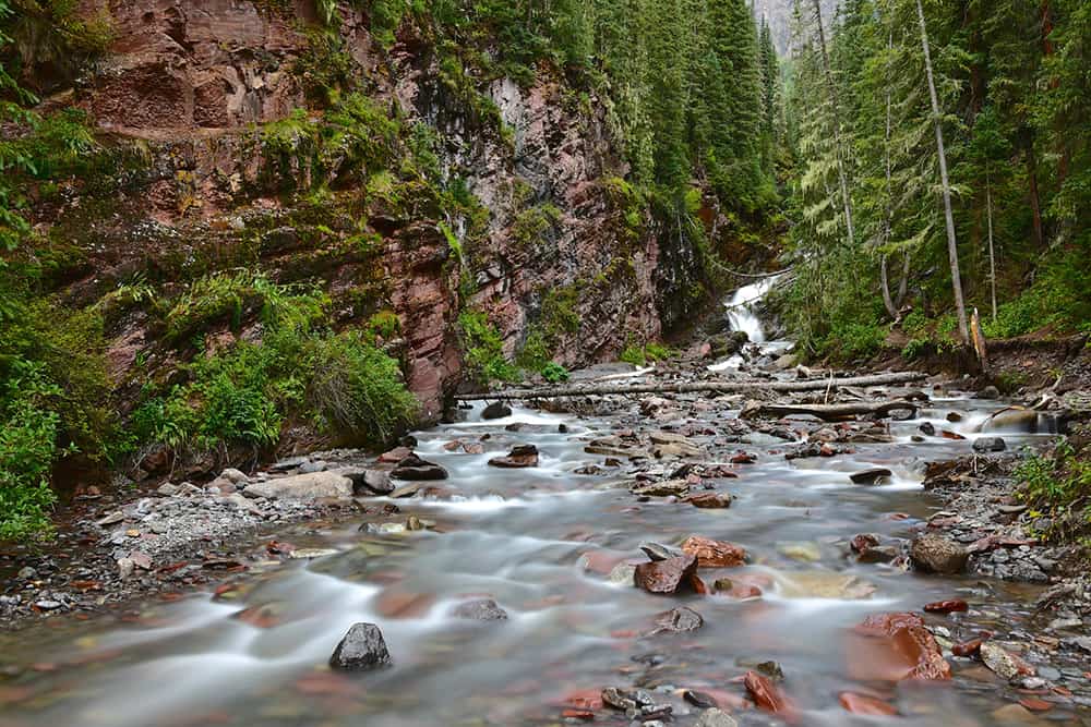
The ascension begins right from the trailhead! Through thick pine forest, the trail switchbacks uphill terrain blotted with creeks and waterfalls. An old mining shaft provides a great reason to take a break and explore before continuing upward.
At just 2 miles in, you’re already at 11,000 feet above sea level. From here, you begin to exit the forest and the terrain flattens out a bit.
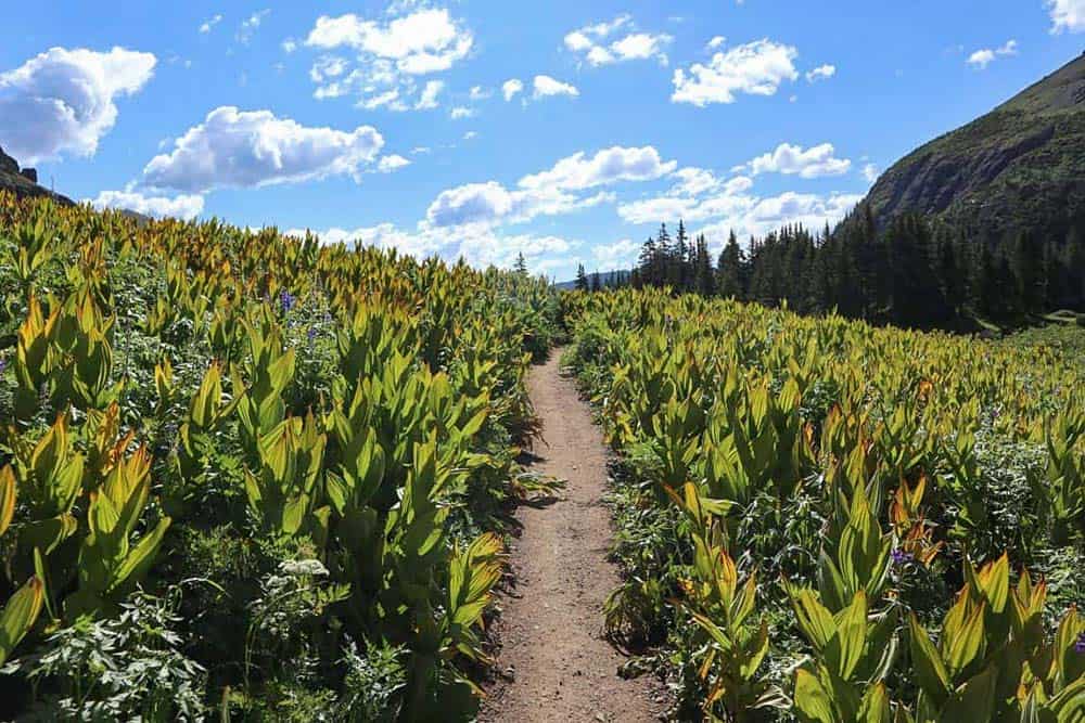
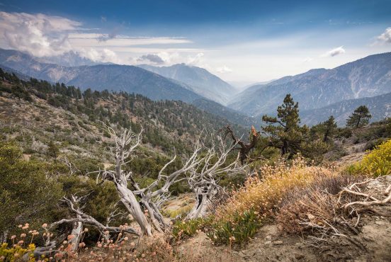
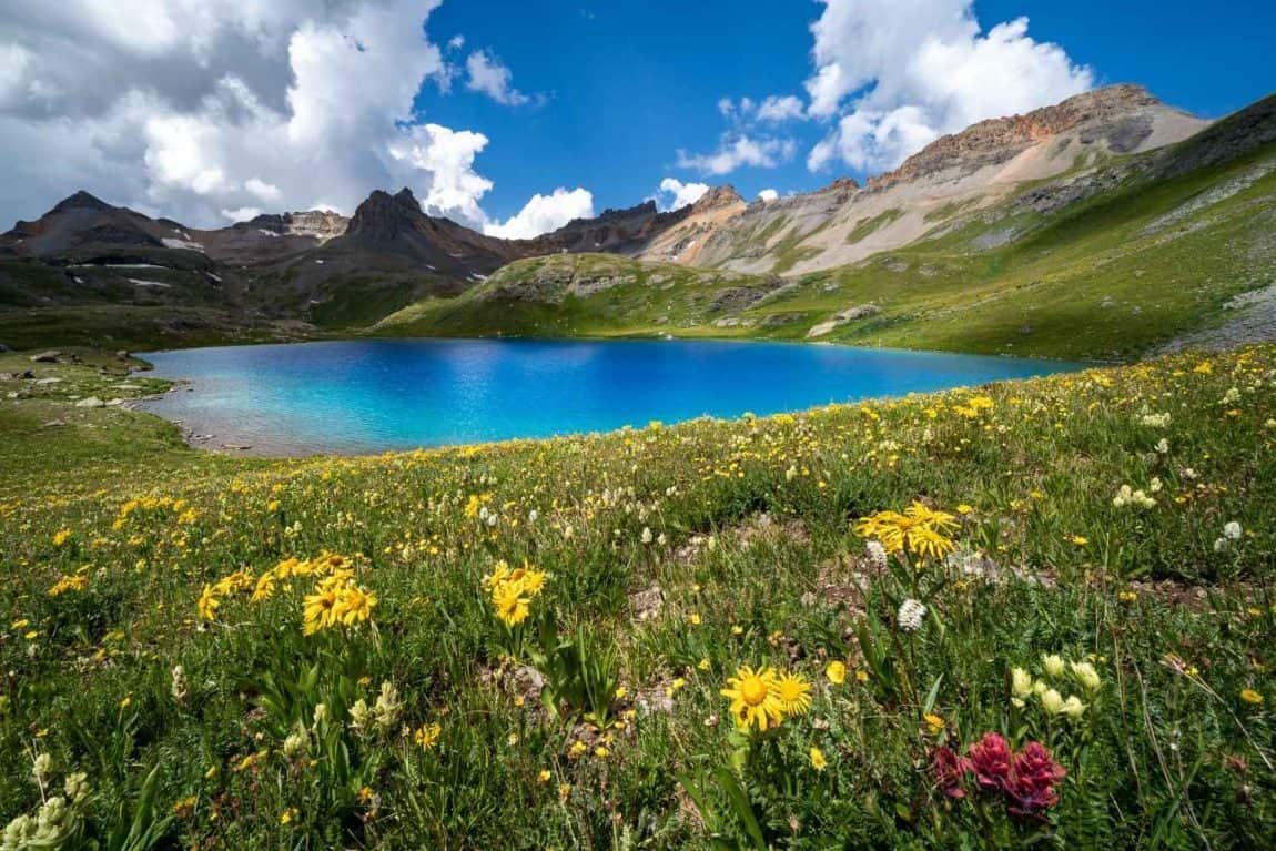
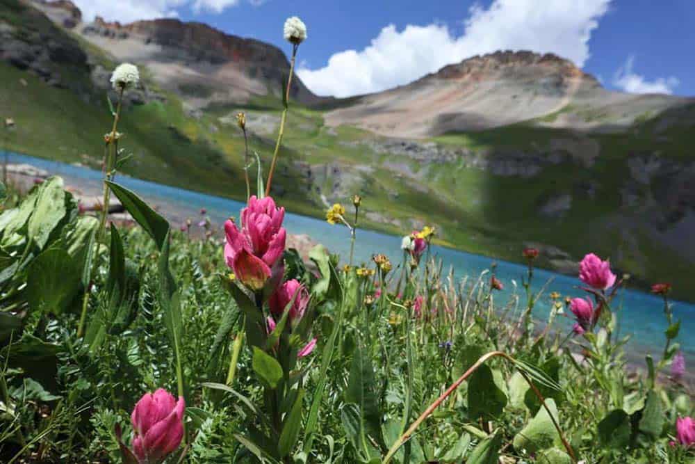
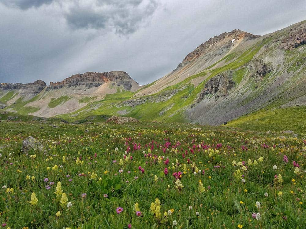
This area is named Lower Ice Lake Basin and looks more like something you would find in Hawaii than Colorado! As soon as you exit the forest, you’re greeted with unique black cliffs dotted with waterfalls, and the jagged Pilot Knob peaking out over the cliffs ahead. The basin floor is filled with crazy wildflowers and 4-foot tall corn-like false hellebore that glow in the sunlight.
Towards the end of this otherworldly scene, you start to see the tiny dots of people making their way up those cliffs up ahead (this is the bit of hiking up 43% grade I mentioned earlier). One piece of advice, don’t get psyched by the “false summit” like we did! We were so excited and thought Ice Lake was right on the other side of this cliff. Not so much.
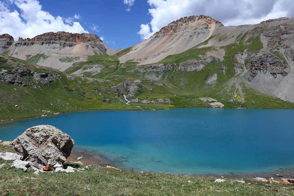
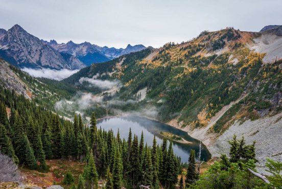
The trail continues to climb, so keep on pushing! And before you know it, you’re at Ice Lake! From here, you can easily see the trail heading south to Fuller Lake, or north to the ever photogenic Island lake. Most hikers stop at Ice Lake for an out-and-back hike rather than following the loop to Island Lake and back. The hike out is smooth sailing — because it’s all downhill!
The most adventurous use this hike as the jumping off point for climbing the high 13ers towering above the Ice Lakes: Ulysses S. Grant Peak, Pilot Knob, Golden Horn, Vermillion Peak, and Fuller Peak. The peaks are tough climbs requiring advanced route finding and scrambling skills, but and well worth the views if you have the experience to tackle them.
When to Visit
This trail sees a lot of traffic due to its stunning views and short-lived hiking season. Ice Lake Basin’s high elevation means there is snow on the trail until late May or June. Prime hiking season of this trail is May to September. July and August are the best months for the basin’s incredible wildflowers.
If you are looking to avoid crowds on the trail, I highly recommend visiting Ice Lake Basin during the beginning or end of the season, and during a weekday. Chances are, it’ll still be very busy! If you have the time, I highly recommend backpacking up to the lakes. Most hikers on this trail are day-hikers, so once the afternoon rolls around, the majority of hikers leave the basin and you might have the place all to yourself and maybe a couple other tents!
The weather in this part of Colorado can be touch-and-go, even in the summer months. Even if the hike in was filled with blue skies and warm temps, come prepared with rain gear and warm layers as afternoon thunderstorms are common. Sun and wind protection is also vital since this trail ascends above timberline.
Additional Read: 11 Best Winter Hiking Destinations in Colorado
Directions to Ice Lakes Trailhead
Unless you are coming from a neighboring small town, getting to Silverton is no short drive. From Denver, it is about a 7 hour drive when you include the usual traffic and driving on windy, two-lane highways.
Due to the popularity of Silverton and Ouray among tourists, signage is abundant. Even the Forest Road 585 is marked very well and you can’t miss it from Highway 550.
Once on Forest Road 585, follow the road until it dead-ends at a large campground on one side, and the trailhead parking lot on the other.
Area Tips and Resources
As mentioned earlier, the Forest Road 585 that you exit onto to get to Ice Lakes Trailhead is open to dispersed camping. There are a few designated campsites along the road that fill up quickly. Other pull offs are abundant, but please stick to the obvious spots that people have camped before to lower human impact of this busy area.
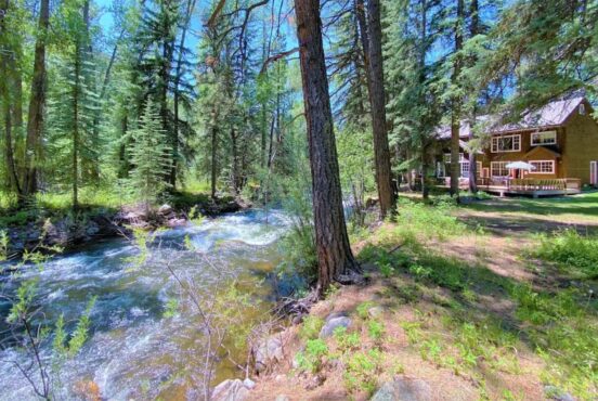
Adjacent to the Ice Lakes Trailhead you will also find the beautiful South Mineral Campground, which has 26 first-come first-served sites, and is open from mid-May through September.
If you are traveling from far away, the ability to camp this close to the trailhead feels like a luxury. It was so nice to drive in the day before we wanted to hike, camp, wake up at our convenience, and head up the trail.
The town of Silverton is roughly a 20 minute drive from the Ice Lakes Trailhead. This makes it easy to refuel or get some much-needed local food after such a tough hike.
Silverton is a very old mining town and only has one paved road going through town. It’s shocking how many visitors this tiny town sees during the summer months, so be prepared for some wait times to the popular restaurants. Avalanche Brewing Company is on the main strip of restaurants and is a great place to relax before moving on to your next adventure!
To the north, Ouray is another great option for food and fun. Ouray is year-round hot spot for travelers. It is an ice climbing, hot springs swimming, and backcountry skiing mecca in the winter, and a rock climbing and backpacking destination in the summer.
Explore Colorado
Check out more of our guides featuring the most beautiful places to explore in Colorado.
Sign up for our free email to join thousands of readers getting epic travel, hiking, camping and gear ideas every week.
Seen in: Colorado, Colorado Hiking, Hikes